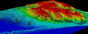
The sheer volume of data generated by remote sensing instruments is staggering. From high-resolution satellite imagery to complex lidar point clouds, the challenge lies not only in acquiring this data but also in transforming it into actionable insights. Digitalization is revolutionizing how we process, analyze, and interpret remote sensing data, enabling us to unlock its full potential.
The Digital Transformation Pipeline:
The journey from raw pixels to meaningful insights involves a series of sophisticated steps:
- Data Acquisition and Preprocessing: Raw data from remote sensing instruments undergoes radiometric and geometric correction to remove sensor errors and atmospheric effects.
- Feature Extraction and Classification: AI and ML algorithms are used to identify and extract relevant features from the data, such as land cover types, buildings, and roads. Deep learning techniques like convolutional neural networks (CNNs) enable highly accurate object detection and semantic segmentation.
- Data Fusion and Integration: Remote sensing data is integrated with other geospatial datasets, such as demographic data, infrastructure data, and climate data, to provide a holistic understanding of Earth’s systems.
- Data Analytics and Visualization: Data analytics tools are used to identify patterns, trends, and anomalies in the data, and interactive visualizations are created to communicate complex information to stakeholders.
- Data Pipelines and Automation: Automated data pipelines streamline the processing and analysis of remote sensing data, enabling near real-time monitoring and analysis.
The Impact of Digitalization:
- Enhanced Accuracy and Efficiency: AI-powered algorithms enable more accurate and efficient data processing, reducing human error and accelerating the pace of analysis.
- Scalability and Accessibility: Cloud computing platforms provide scalable storage and processing resources, making remote sensing data more accessible to a wider range of users.
- Real-time Monitoring and Decision-Making: Automated data pipelines enable near real-time monitoring of environmental changes and disaster events, supporting rapid response and decision-making.
- Data-Driven Insights for Sustainable Development: Digitalization enables the extraction of valuable insights from remote sensing data, supporting sustainable development goals and informed policy decisions.
Ready to contribute to a more sustainable future with digital Earth technologies? We can help you implement data-driven solutions. Contact us to discuss your initiatives
Interested in leveraging remote sensing for your sustainability goals? Let’s explore how we can collaborate. Contact us today